ROAD TRIPS
10 WORLD`S MOST EXTREME ROAD TRIPS
Dangerous yet scenic and action-packed; road trips through isolated and hostile regions have always drawn motorists. For some, extreme driving is like an addictive drug. No wonder, the feeling of having one`s heart in their throat brings the ultimate adrenaline rush. Surely, hitting a dangerous path is a rewarding experience – for all the thrill, jaw-dropping views and lifelong memories. So, if you are a passionate and daring driver, you should add one of the following to your bucket list!

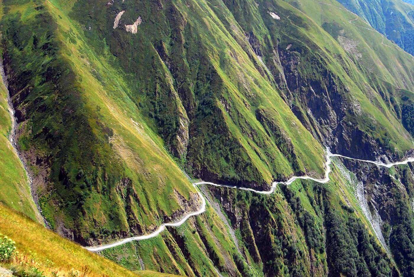
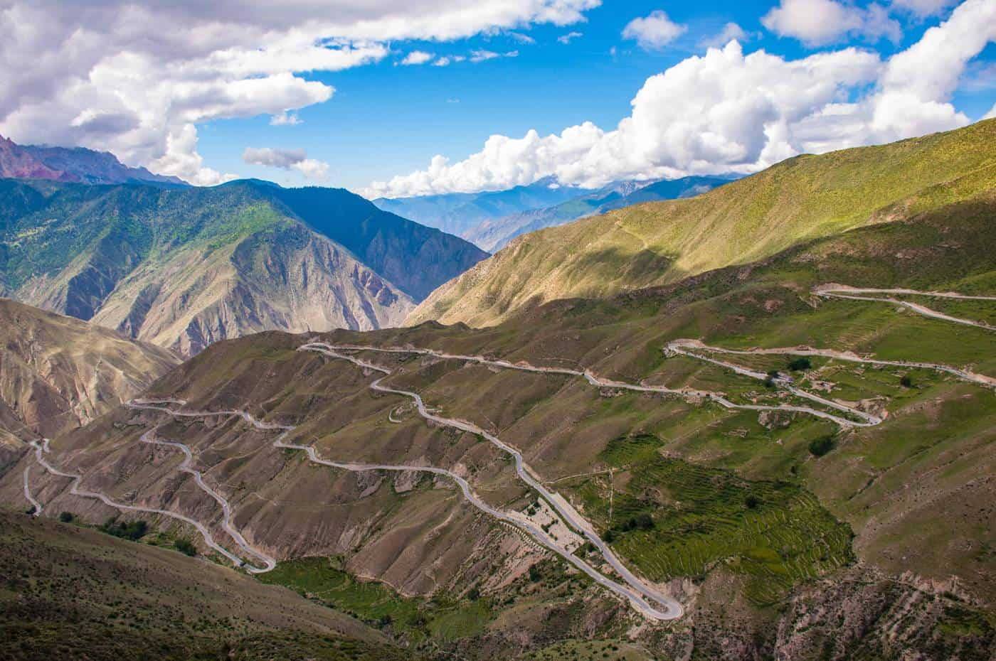
The Road to Tusheti in the Caucasus Mountains is considered to be one of the most treacherous roads on Earth (Georgia)
1.EL CAMINO DE LA MUERTE (BOLIVIA)
Internationally known as the North Yungas Road, El Camino de la Muerte (Death Road) is a 60 km long track, built by prisoners in the 1930s. The road takes you from the Bolivian capital of La Paz to the town of Corioco. Being almost a banality, the trail was repeatedly rated as the most dangerous road on Earth.
Traffic travels in both directions, but the road is not more than 3 metres wide, and there are no guard rails. Tropical setting, frequent heavy rains, and fog add to the hazard, and one single miscalculation could result in a fall off the cliff up to 600 meters high.

El Camino de la Muerte, ‘Death Road’ rated as the world`s most dangerous road (Bolivia)
The Death Road has claimed hundreds of lives and crosses mark the spots where vehicles have previously fallen. The track has been improved in recent years, and a new section now bypasses the most hazardous part, but the original route is still highly popular with cyclists.

The most hazardous section of the ‘Death Road’ is now mostly used by cyclists (Bolivia)
2.KOLYMA HIGHWAY (RUSSIA)
Yakutsk is a Siberian region where the coldest temperatures outside Antarctica were recorded (-64.4°C). Yakutsk is also the largest city built on continuous permafrost. Houses here are built on concrete piles because of the frozen ground.
For those who are intending to reach the Pacific Coast overland and meet the Trans-Siberian Railway at Skovorodino, there is no other way but following the Lena Highway, once said to be the world`s worst highway. Stretching along the Lena River, the road eventually connects to the ill-famed Kolyma Highway, locally knows as “The Road of Bones.”

The Kolyma Highway, ‘The Road of Bones’ was rated as the world`s worst highway (Russia)
During winter, which normally lasts around ten months, the track is constantly subject to heavy snowfall, ice, and almost zero visibility. Funnily enough, the worst time of a year for most of the drivers is summer – once the snow has melted the road turns into a sea of mud. The highway wasn`t paved until 2014 (the locals would say that it was supposed to keep the Germans away), and it might well have been so in the past.
Today, the Germans ‘away’ and the surface is sealed, but for all that the Kolyma road situation has not much improved. Summer still often makes it impossible to drive through certain sections, even for the locals. Seeing extensive traffic jams and vehicles being slowly swallowed by the mud is not a rare image. And this is a perfect scenario for the notorious ‘Siberian mud pirates’ – armed groups of the local men who patiently wait for summer so they can rob the helpless motorists when stuck in dirt.
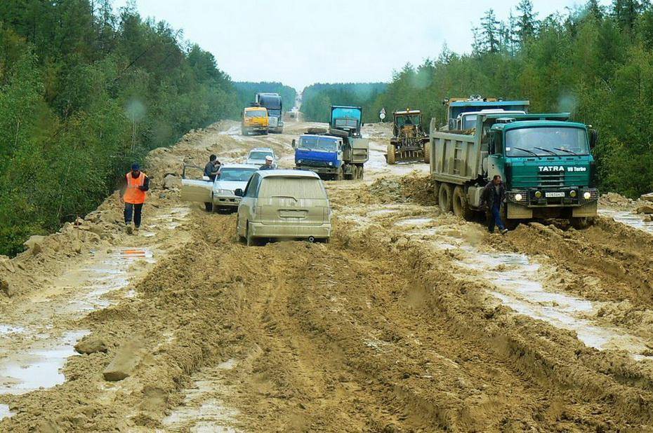
Summertime in Siberia makes the road turn into a sea of mud, Kolyma Highway (Russia)
DID YOU KNOW?
There is not even one bridge (yet) anywhere to cross the half-frozen Lena River, and the only transport are hydrofoils and helicopters (only open between May and October). Although, the Chinese investors are willing to fund building a permafrost crossing of the river to bring more visitors to China, when (and if) this is going to happen is uncertain.
3.HINDUSTAN TIBET ROAD (INDIA)
National Highway 22 is an old trading route, and part of the ancient Silk Road, running 500 km from Punjab to Tibet, via the jaw-dropping Shipki La Pass, where Heinrich Harrer once crossed the border to spend “7 years in Tibet”. Today, the mountain pass is only permitted to cross for the locals, but anyone can drive at least to the Tibetan border, which is a scenic and super-exciting drive.

Hindustan Tibet Road, part of the ancient Silk Route (India)
The whole thrill starts at Shimla, where the road turns into a mountainous track, with rough terrain and continuous hairpin bends, and if you are a fan of extreme off-road driving, you will love the adrenaline rush in the Kinnaur Valley. Carved into vertical cliffs the road is a masterpiece of the Indian engineering.
The famous Tranda ‘dhank’ section at is the most exhilarating, and the deadliest. Already tunnelling of the hanging cliffs over the wild Sutlej River claimed many lives during the construction in the 19th century. Now, the locally claimed ‘world`s most treacherous road,’ is considered to be ‘stable,’ yet lethal accidents frequently happen, despite the road being open only in summer.
If you have a few extra days, you can return via the beautiful Spiti Valley. Past Khab, there is another electrifying adventure to enjoy – the cliff-hanging drive through Malling Nala.

Tranda ‘dhank’ section, Kinnaur Valley (India)
4.GUOLIANG TUNNEL (CHINA)
This magnificent tunnel-road was built by the local villagers in the rugged Taihang Mountains of the Hunan Province of China. It took them five years to complete this masterpiece: 1200 meter long tunnel, 5 meters high and 4 meters wide.
Many of the builders died during the construction, and many others endured the tough weather conditions and hard work. Eventually, their efforts paid off, and in 1977 the tunnel was open to traffic. The Guoliang Tunnel road is another hair-raising driving experience that does not tolerate any mistakes. Nevertheless, it is a popular scenic route and a key tourist destination on the Chinese map.
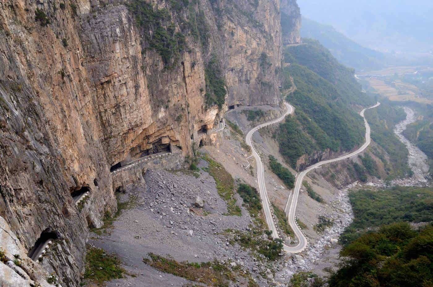
The construction of the famous Guoliang Tunnel has claimed many lives (China)
5.RUTA NACIONAL 5 (CHILE)
Chile’s the Atacama Desert is one of the driest places on our planet. It’s said that in some areas, the average annual rainfall is zero, and it’s been that way for centuries. While most of the desert stretches across Bolivia, Peru, and Argentina, the central part belongs to Chile.
This is exactly where to look for one of the most dangerous roads on our planet – Ruta Nacional 5. The northern part of the highway crosses the Atacama Desert from the Peruvian at Arica to Iquique, with only very few gas stations and far between.

Ruta Nacional 5 through the Atacama Desert (Chile)
Wind is a serious issue here since the region is known for gusty gales so strong that they can easily blow your vehicle off the road and throw you down a valley – numerous vehicle skeletons lying at the bottom speak for themselves.
However, what the main danger factor causes most of the accidents is the monotony: hundreds of miles through endless, empty lines and the heat often lead to exhaustion, loss of concentration and mirage. On the gutters, there are small mausolea in memory of those who gave their lives to the road.

A bus wreck at the road, Ruta 5 (Chile)
DID YOU KNOW?
The Atacama Desert is believed to be home to the “Arica Monster” – a big surviving member of the feathered theropod dinosaur. Many motorists driving the Iquique-Arica route reported spotting a large and weirdly looking animal that resembled something between a dinosaur-emu and a kangaroo. In 2004, the largest number of drivers (some in groups) claimed to see an animal of the same description. However, such existence of a prehistoric species in the area has never been officially confirmed, and so, if dinosaurs really live in the vast Atacama desert remains a mystery.
6.MANALI-LADAKH-SRINAGAR ROAD (INDIA)
It is only about 500 km from Manali (Himachal Pradesh) to Leh-Ladakh, situated in the province of Kashmir. Absolutely staggering, and extremely dangerous; the journey leads through snow-capped mountains, half-frozen streams with no bridges and cruel weather, with the highest elevation of 5328 m at Tanglang La.
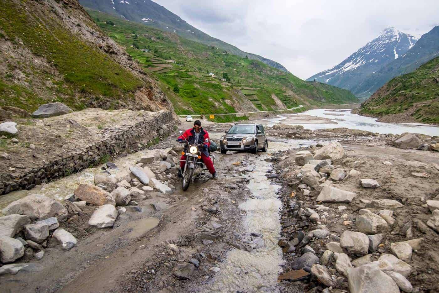
The road between Manali and Ladakh is subject to flooding throughout a year
It is the “Corpse Field Pass” – as the locals call it, which has the worst reputation. The name of India`s oldest mountain pass reflects the hazard that should never be underestimated when crossing the Rohtang Pass (3978 m); even though the ancient trade route is only open in the ‘mildest’ season (Jun-Oct) too many motorists and vehicles have succumbed to the harsh weather and road conditions – the corpses along the highway are serious warnings to all drivers.

The Zoji La Pass, the Indian Himalaya
Most of the road trippers will want to continue for another 400 km, from Ladakh to Srinagar, via the treacherous Zoji La pass (3528 m). The 9 km long, very narrow trail runs through rough terrain with no protective barriers where snow cutting machinery is essential to make the road passable as the snow carpet here can be up to 25 meters deep. The highly perilous journey is often accompanied by snowstorms and landslides, yet it provides a vital link between Ladakh and the Kasmir Valley.

The Magnetic Hill, optical illusion gives an impression that the road rolls uphill (India)
TRAVEL TIP
Past Leh, there will be an extraordinary natural wonder to drive through: The Magnetic Hill is a ‘gravity hill’ known for an optical illusion that the cars are driving uphill which is, in fact, a downhill road. Also, if you have an extra day or two, turn off the road at Leh and take the 40 km long diversion up to Khardung La (5359 m) – one of the world`s highest drivable mountain passes, which eventually leads to the Siachen Glacier.
7.SICHUAN HIGHWAY (CHINA)
The ‘big north line’ between China and Tibet is more than 2412 km long, high-elevation highway built from Chengdu to Lhasa, which traverses 14 mountain ranges in Himalaya, with the average altitude of 4000-5000 m. The road passes through rugged mountains, and primeval forests filled wild rivers and wildlife, and as of 2017, the highway includes the highest vehicular tunnel in the world (Chola Mountains, 6168 m).

A steep incline on the Sichuan Highway (China)
Even though it is an adventurous journey to travel from China to Tibet overland, with some of the world`s most impressive mountain sceneries, there is danger around every corner – the road claims hundreds of lives every year.
Driving the northern route to Tibet, you will be crossing several rivers – Nu-Jiang, Jinsha, Dadu and Lantsang – and these can be tricky. Regular landslides and rock avalanches cause serious damage to the roads and bridges, and high in the mountains, oxygen is scarce, and temperatures feature swings of up to 40 degrees over a single day.
The Nujiang Highway 318 has 72 turns at Baxoi (China)
The southern line might not be as high but what makes the road trip risky is the section at Baxoi on the Nujiang Highway 318. Here not only harsh weather but the road itself presents great challenges: 72 turns along a 35 kilometre stretch swing down the mountainsides, starting at the 4,658 meter-high Yela Mountain, before descending to the Nujiang Bridge – the most dangerous section, where water roars up to 150 meters below and the cliffs, soaring 1,000 meters high.

Jinsha river crossing (China)
It almost seems like no one would even think of taking the risk to set out on this long, perilous journey. Yet, for the indigenous people, the bridge is vital to link to the outside world so they can bring food, clothing, kitchenware, jewellery and other daily necessities to the nearby markets. At least, there is a proper bridge now, as in the past the locals had to use a crude system of ropes to cross the wild river.
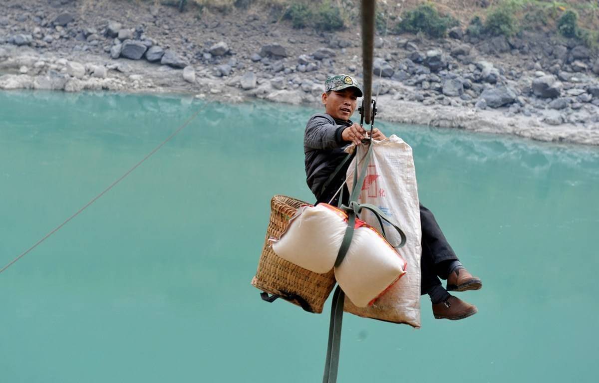
The traditional Himalayan rope river crossings are slowly being replaced by bridges (China)
8.OLD TELEGRAPH TRACK (AUSTRALIA)
To reach the northernmost point of Australia – Cape Yorke – is on the bucket list of every Australian. The cape is separated from Papua New Guinea by the narrow Torres Strait, and it is an extremely isolated region filled with swamps, billabongs, and crocodiles.
The 1000 km long off-road journey takes the adventurers through ancient rock art, Aboriginal culture, tropical wilderness, stunning waterfalls, red outback tracks, gold town ruins and remote WWII sites. The Peninsula Developmental Road, starting at Cairns, is an unsealed track and due to heavy rains often muddy with several river crossings.

The Old Telegraph Track includes several fairly deep river crossings (Australia)
The best part – and the riskiest – is the 80 km long Old Telegraph Track, only accessible during the dry season (May-Oct). The road is notorious for the ‘Gunshot’ (almost vertical crossing), the highlight of the road trip, only doable using a high ground clearance vehicle.
Deep creek crossings, steep and muddy river banks, no facilities and no phone coverage do not make it any easier. Besides, both freshwater and saltwater crocodiles inhabit the rivers and streams of the Far North of Queensland; quite tempting unless you don`t mind having your heart in your throat!

The notorious ‘Gunshot’ is the highlight along the Old Telegraph Track (Australia)
9.VAN ZYL`S PASS (NAMIBIA)
Africa Overland! This is an extreme cross-country drive running through the desert, and the absolute highlight is the tricky descent at the Van Zyl`s Pass that leads to spectacular Marienfluss Valley.
It is not exactly a road; rather a route made over the mountain by the travellers over time. The pass provides a pure adrenaline rush, but be aware that the which leads up to it is a 10-15km of challenging 4×4 driving where one has to dodge their way through rocks, boulders, badlands, and ravines. The track is only drivable one way – downwards – the direction to the Marienfluss.

Van Zyl`s Pass (Namibia)
Towards the end, the road descends to the ancient glacial Marienfluss Valley – one of the Earth`s most beautiful sights. There are some camping facilities in Kaokoland, and if you ever pluck up the courage to undergo this trip, you are guaranteed to meet the real ‘Mamma Africa’ with everything that belongs to it.
Remember that this off-road venture is only suitable for experienced off-road drivers unless you hire a local driver.
10.DALTON HIGHWAY (ALASKA)
Similarly to the Siberian roads the 414 miles, long James Dalton Highway is an arctic and partially gravel trail. Also called, Alaska Route 11, it starts at Fairbanks and ends at Deadhorse, near the Arctic Ocean. The highway parallels a pipeline, and it is still the main supply route for the Prudhoe Bay oilfields.

Alaska Route 11 (USA)
It is one of the most isolated roads on the continent hence if you decide to use this route you need to be aware that you highly likely come across nothing but occasional tracks and tractor-trailers.
Although the aurora borealis is a tempting tourist attraction, most of the rental companies would not even allow their cars on this highway: clouds of gravel kicked up by the speeding trucks, potholes take a heavy toll on cars and services, gas, and repairs are practically nonexistent.
Moreover, in winter time some sections of the road get icy and driving these requires certain experience. If you insist on doing this, however, you will absolutely need 4×4, a CB radio, extra fuel, food, tires, and a trunk filled with supplies. Remember that you are in a grizzly country and you certainly don`t want to get stuck in the middle of nowhere!
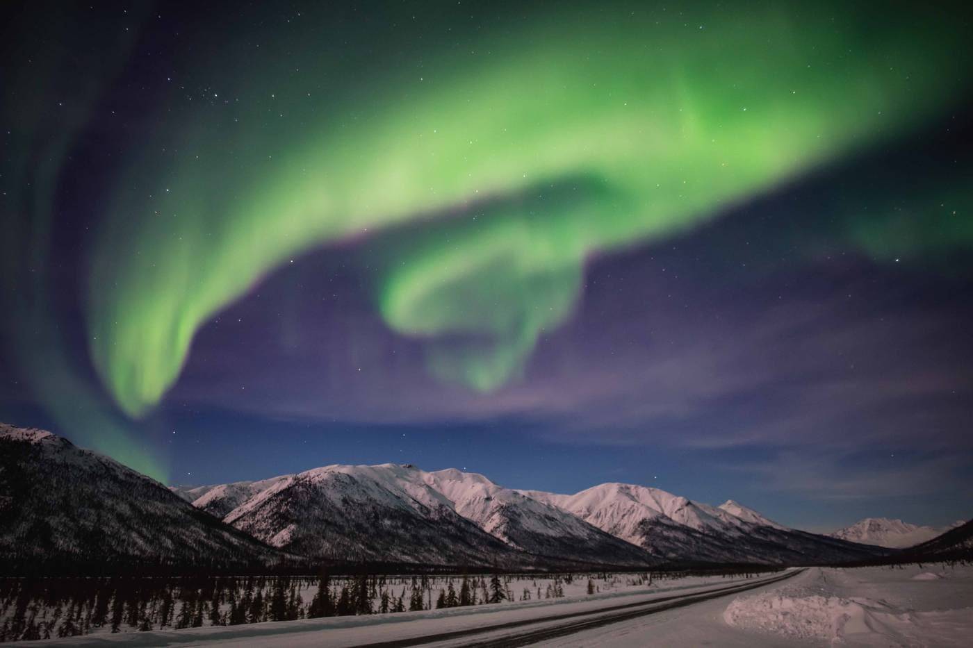
The Northern Lights at the Dalton Highway (Alaska)
HAVE FUN DRIVING AND STAY SAFE! 🙂
Read Next
Eva Bodova
Sunday 25 November 2018
Mini Gallery
Book Your Accomodation
Search hotels and more...
YOU MAY ALSO LIKE
ROAD TRIPS

ROAD TRIPS